Global analysis: subsidence in deltas often faster than sea level rise
River deltas are among the most densely populated and economically vital areas worldwide but they are exposed to increasing risks from relative sea level rise. New high-resolution satellite analyses (InSAR with Sentinel-1, 2014-2023) show that land subsidence in forty deltas on five continents is widespread and, in many cases, faster than sea level rise. The study provides consistent, delta-wide measurements at 75 m resolution and it has now been published in Nature.
Subsidence increases the threat to vulnerable deltas worldwide
“We already knew that rising sea levels are a threat to these valuable delta areas but the fact that they are subsiding in so many places around the world is intensifying the effect and therefore exacerbating the risks of flooding, land loss and salinisation,” says Philip Minderhoud, a researcher at Deltares and Wageningen University and Research Centre, and co-author of the article 'Global subsidence of river deltas'.
“For many deltas, there is a major shortage of ground-based observations of elevation and subsidence. That makes it difficult to quantify the overall vulnerability of these deltas accurately. It is relatively expensive and time-consuming to establish a clear picture of subsidence in an entire delta with direct measurements – let alone forty major delta systems worldwide – even though that is necessary as a basis for effective action.”
New satellite insights expose widespread elevation loss in vulnerable deltas
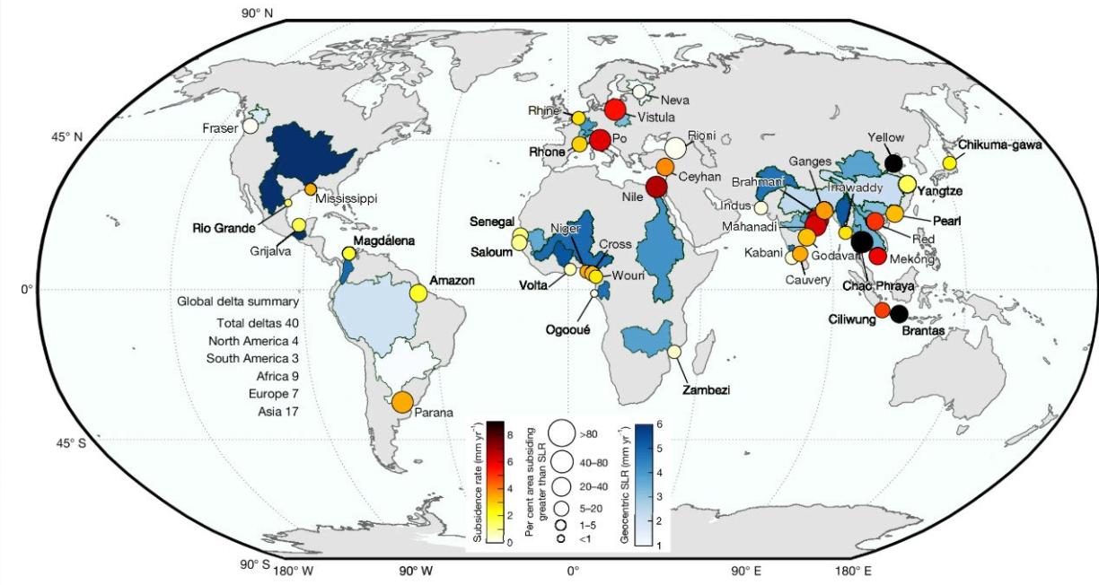
fig. 1 Each circle represents the location of the 40 deltas evaluated in this study, colour-coded by the average land subsidence rate. The size of the circle represents the percentage of the delta area subsiding faster than geocentric SLR. For visualization purposes, the geocentric SLR rate is shown as a colour gradient over entire watersheds or basins, although this does not represent the actual extent of exposure. Global coastlines are based on public-domain data from the CIA World DataBank II (using GSHHG (Global Self-consistent, Hierarchical, High-resolution Geography Database)), distributed with MATLAB. The delta basin polygons were obtained along with the sediment flux dataset from ref. 29.
More than 50% of deltas are subsiding by more than 3 mm annually
More than half of the deltas have subsidence rates exceeding 3 mm per year. In thirteen of these deltas – the Nile, Po, Vistula, Ceyhan, Brahmani, Mahanadi, Chao Phraya, Mekong, Red River, Ciliwung, Brantas, Godavari and Yellow River – average land subsidence exceeds the current estimates of global sea level rise, in other words about 4 mm per year. Average land subsidence in the deltas of the Chao Phraya (Thailand), Brantas (Indonesia) and Yellow River (China) is more than twice current global sea level rise.
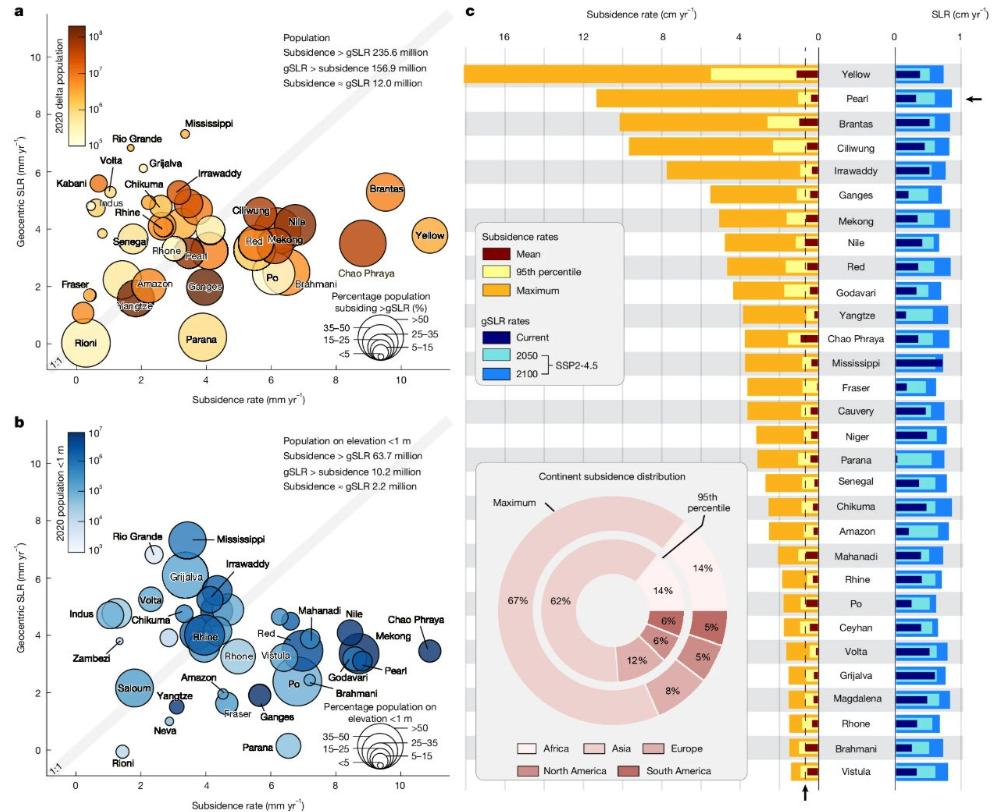
fig. 2 a, Bubble plot comparing geocentric (absolute) SLR (mm yr−1) and land subsidence (mm yr−1) across 40 deltas. Deltas in which subsidence rates exceed geocentric SLR fall to the right of the 1:1 line, whereas those in which geocentric SLR exceeds subsidence fall to the left. Bubble colours indicate the total delta population, ranging from fewer than 100,000 (lighter colours) to more than 100 million (darker colours). Bubble size represents the percentage population living in delta land areas subsiding faster than geocentric SLR. b, Same as a, but considering only the population living at elevations below 1 m. Note that the Brantas and Yellow River deltas have values greater than 15 mm yr−1 and are not represented on the plot for visual clarity. c, Bar plots comparing the range of land subsidence rates, contemporary and projected SLR for 30 representative deltas. The maximum subsidence rate is calculated as the median of the 50 highest rates to avoid biases from single extreme values. The dashed vertical line shows the maximum 2100 projected SLR rate across all deltas.
Groundwater extraction main factor in subsidence
In ten of the forty deltas, groundwater extraction is the main factor driving subsidence. Anthropogenic interventions have accelerated land subsidence in many of the world’s major deltas. They include excessive groundwater extraction, oil and gas extraction, and changes in land use associated with urbanisation, agriculture and aquaculture.
Deltas where large amounts of groundwater are extracted and where population growth is higher tend to have higher rates of subsidence. Examples include the deltas of the Yellow River, the Po River, the Nile River, the Chao Phraya River and the Mekong River.
Deltas are subsiding faster than sea rise
The new observations show that, for most deltas in the twenty-first century, the current rate of subsidence is exceeding global sea level rise due to global warming as the main cause of relative sea level rise. Targeted measures are needed to address subsidence, alongside broader action to mitigate global sea level rise caused by climate change and adapt accordingly.
“Our findings are very worrying and they require a proactive approach to the problem,” says Minderhoud. The good news is that government authorities can institute measures locally to mitigate rapid land subsidence caused by human activity.
For example, limiting the amount of groundwater extraction has significantly reduced land subsidence in delta cities such as Shanghai, Bangkok and Ho Chi Minh City. This also opens up effective options for the wider, surrounding delta areas to tackle relative sea level rise at the local level without waiting for a global consensus.
Graphs taken from: Ohenhen, L.O., Shirzaei, M., Davis, J.L. et al. Global subsidence of river deltas. Nature (2026).
来源:Deltares
Subsidence in deltas often faster than sea level rise | Deltares